 eAtlas Data Catalogue
Great Barrier Reef Marine Park Authority
Type of resources
Available actions
Topics
Keywords
Contact for the resource
Provided by
Years
Formats
Representation types
Update frequencies
status
-
Traditional use activities in the Great Barrier Reef Marine Park are managed under the Great Barrier Reef Marine Park Act 1975, and the Great Barrier Reef Marine Park Regulations 2019. The Great Barrier Reef Marine Park Zoning Plan 2003 recognises that under section 211 of the Native Title Act 1993, native title holders may undertake traditional use of marine resources in the Great Barrier Reef Marine Park. eAtlas Notes: This is not the authoritative metadata for this dataset. The authoritative source is available from the GBRMPA data portal https://geoportal.gbrmpa.gov.au/datasets/GBRMPA::gbrmpa-traditional-use-of-marine-resources-agreement-tumra-areas. This metadata is retained in the eAtlas to include any additional notes and description about the dataset. Traditional Use of Marine Resources Agreements are community-based plans for management of traditional resources which are accredited in legislation and have proved a successful mechanism for joint management of the Reef. Traditional Use of Marine Resources Agreements describe how Great Barrier Reef Traditional Owner groups work in partnership with the Australian and Queensland governments to manage traditional use activities on their Sea Country. Each Traditional Use of Marine Resources Agreements has a committee to manage the agreement and traditional use of marine resources in their Sea Country, including traditional take, if any of important species such as dugongs and turtles. Their management of traditional use is based on both cultural lore and contemporary science and are also used for broader Sea Country planning and management. Description of the data: The following are the list of TUMRAs included in this dataset: - Dharumbal Region Woppaburra Section: Offshore area including the Keppel Islands Group and the surrounding waters. - Girringun: Offshore area between Rollingstone and Mission Beach, including Hinchinbrook and Dunk Islands, but excluding the Palm Island Group. - Wuthathi: Offshore area between Captain Billy Landing and the mouth of the Olive River, extending east past Raine Island. - Port Curtis Coral Coast: Extending from the entrance of Port Alma south to Burrum Heads, including Curtis Island and the Capricorn and Bunker Island groups. - Yuku Baja-Muliku: Monkhouse Point south to Forsberg Point and extending east to just past the Ribbon Reefs. - Lama Lama: Near Massy Creek, east to Hedge Reef and south through Princess Charlotte Bay to the Normanby River in the south. - Yirrganydji: Area between Port Douglas and Cairns, extending east past Spur, Onyx, Nicholas and Hope Reefs. - Gunggandji: Green Island, Michaelmas Cay, Fitzroy Island, and the surrounding waters. - Mandubarra: Offshore areas between the mouth of Mourilyan Harbour south to Kurrimine Beach, extending east past Armistice Reef. Change Log: 2023-07-24 Dataset setup in eAtlas based on most recent available version of data from 2020-03-11
-
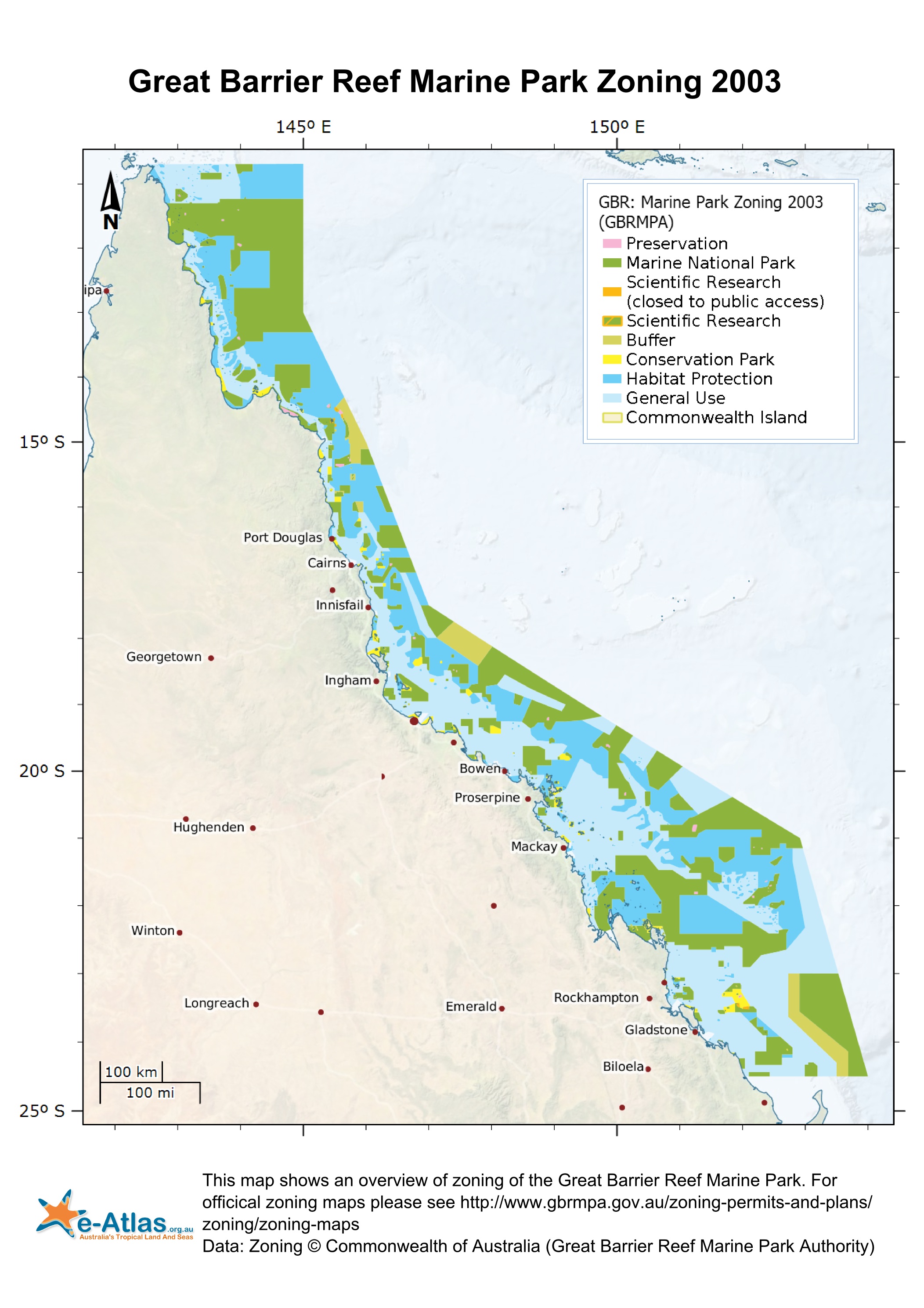
This dataset corresponds to the zoning within the Great Barrier Reef Marine Park effective 1st July 2004. It is derived from the Great Barrier Reef Marine Park Zoning Plan 2003. The Great Barrier Reef Marine Park is a multiple-use area. Zoning helps to manage and protect the values of the Marine Park that users enjoy. Zoning Plans define what activities occur in which locations both to protect the marine environment and to separate potentially conflicting activities. Revised zoning of the Great Barrier Reef Marine Park was introduced in July 2004 as part of the Great Barrier Reef Marine Park Authority's Representative Areas Programme. Between 1999 and 2004, the Great Barrier Reef Marine Park Authority undertook a systematic planning and consultative program to develop new zoning for the Marine Park. The primary aim of the program was to better protect the range of biodiversity in the Great Barrier Reef, by increasing the extent of no-take areas (or highly protected areas, locally known as ‘Green Zones’), ensuring they included 'representative' examples of all different habitat types - hence the name, the Representative Areas Program or RAP. Whilst increasing the protection of biodiversity, a further aim was to maximise the benefits and minimise the negative impacts of the rezoning on the existing users of the Marine Park. Both these aims were achieved by a comprehensive program of scientific input, community involvement and innovation [1]. In each zones there are a range of activities that are allowed, disallowed or require a permit. The following outlines a summary of activities that are disallowed in each zone. Please refer to [2] for a more detailed and authoritative description of all restrictions within each zone: * General Use Zone: General use, some activities require a permit. * Habitat Protection Zone: No trawling, some activities require permits. * Conservation Park Zone: No trawling, limited crabbing and line fishing. * Buffer Zone: No aquaculture, bait netting, crabbing, harvesting fishing, collecting, spearfishing, line fishing, netting and trawling. Trolling for pelagic fish is allowed. * Scientific Research Zone: Research areas primarily around scientific research facilities. Same as Buffer zone but with no trolling. * Marine National Park Zone (Green): 'no-take' area. The following are allowed: boating, diving, photography and limited impact research. Some other activities are allowed with permits. * Preservation Zone (Pink): 'no go' area. No activities are allowed except research activities with a permit. Official maps derived from this dataset can be downloaded from the GBRMPA Zoning Maps [3] page. This dataset can now be downloaded directly from GBRMPA's Geoportal. This metadata was prepared for the eAtlas and is not authoritative. Please contact the Great Barrier Reef Management Authority for an authoritative record. Data Location: This dataset is filed in the eAtlas enduring data repository at: data\other\GBR_GBRMPA_Zoning-2003
-
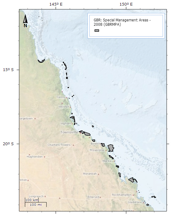
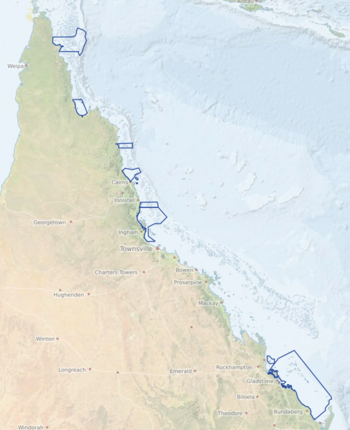
This dataset contains the amalgamated set of Special Management Areas (SMAs) in the Great Barrier Reef Marine Park as described in the Great Barrier Reef Marine Park Regulations 1983, Amendments 2008. This includes: SMA - No Dories Detached, SMA - Princess Charlotte Bay, SMA - Public Appreciation, SMA - Restricted Access, SMA - Seasonal Closure, SMA - Dugong Protection Area B, SMA - Dugong Protection Area A, SMA - Natural Resources Conservation Dugong Protection Areas: This layer shows the Special Management Areas that provide additional protection for Dugongs from commercial fishing. The Dugong Protection Areas ban or restrict the use of commerical netting within these areas. Zone 'A' Dugong Protection Areas include significant dugong habitats in the southern Great Barrier Reef. In these areas, the use of offshore set, foreshore set and drift nets are prohibited, except in Hervey Bay and Great Sandy Strait Protection Area where specialised fish netting practises are allowed to continue with modifications. The use of river set nets are allowed with modifications in Zone 'A' Dugong Protection Areas, except in two key areas where river set nets are prohibited (Hinchinbrook and Shoalwater Bay Dugong Protection Areas). Other netting practices such as ring, seine, tunnel and set pocket netting which are not considered to pose a serious threat to dugong are unaffected. In Zone ‘B' Dugong Protection Areas mesh netting practices are allowed to continue, but with more rigorous safeguards and restrictions than before. Princess Charlotte Bay: This Special Management Area has been designated to protect dugong within Princess Charlotte Bay in the Far Northern Management Area of the Marine Park. The Special Management Area requires commercial net fishers to obtain a permit to operate within Princess Charlotte Bay. Public Appreciation: These Special Management Areas restrict spearfishing, commercial aquarium fish collecting, coral harvesting, beachworm harvesting, and aquaculture from being undertaken. Restricted Access: These areas may not be used or entered without written permission. In addition, shore access to many islands may be restricted or restricted seasonally. Please refer to the Department of Environment and Resource Management for more information. Seasonal Closure: The Ribbon Reefs and adjacent areas are unique, as they are located at a particular part of the continental shelf, which drops sharply away from the reef edge. These important areas of reef support diverse species, including large pelagic fish such as marlin. Special Management Areas designated in these areas provide additional protection to the Ribbon Reefs and adjacent habitats. These Special Management Areas prohibit all fishing and detached dories in these areas from 1 January to 31 August each year. No Dories Detached: This layer shows the boundaries of the No Dories Detached Special Management Area specified within the Great Barrier Reef Marine Park Amendment Regulations 2004. This Special Management Area regulates the number of dories that may be detached from a commercial fishing vessel. Natural Resources Conservation: There is a Natural Resources Conservation Special Management Area declared for: Mermaid Cove, Lizard Island Locality 1 In addition to the rules for the Conservation Park (yellow) Zone, you cannot spearfish or conduct fishing or collecting in this area, except for trolling and bait netting for pelagic species. This metadata record was created for the eAtlas and is not authoritative. Please contact GBRMPA for more information. To obtain this dataset go to the GBRMPA spatial information website, download the appropriate data usage agreement and send it through to gis@gbrmpa.gov.au. To cite this dataset in the eAtlas: Great Barrier Reef Marine Park Authority, (2008). Special Management Areas (SMA) within Great Barrier Reef Marine Park. eAtlas Archive. https://eatlas.org.au/data/uuid/41dd5285-88ec-40c3-be85-f3e0b7c80c27
-
This record details the TUMRAs that were in effect in 2009. Since then the number of TUMRAs has significantly increases. For the latest agreements refer to GBRMPA. A more recent version of this dataset is available on the eAtlas: https://eatlas.org.au/data/uuid/e180cca5-d652-4292-8272-69ac94977e6b Traditional use activities in the Great Barrier Reef Marine Park are managed under the Great Barrier Reef Marine Park Act 1975, and the Great Barrier Reef Marine Park Regulations 1983. The Great Barrier Reef Marine Park Zoning Plan 2003 recognises that under section 211 of the Native Title Act 1993, native title holders may undertake traditional use of marine resources in the Great Barrier Reef Marine Park. Traditional Use of Marine Resources Agreements (TUMRAs) are formal agreements developed by Traditional Owner groups and accredited by the Great Barrier Reef Marine Park Authority (GBRMPA) and the Environmental Protection Agency (EPA). TUMRAs describe how Traditional Owner groups work with government to manage traditional use activities in sea country. A TUMRA may describe, for example, how Traditional Owner groups wish to limit their take of turtle and dugong, their role in compliance and their role in monitoring the condition of plants and animals, and human activities in the Great Barrier Reef Marine Park. For more information see the Sustainable traditional use of marine resources: http://www.gbrmpa.gov.au/corp_site/key_issues/conservation/indigenous_partnerships/sustainable_traditional_use_of_marine_resources NOTE: The data associated with this record is out of date and should only be referred to for historic purposes.
-
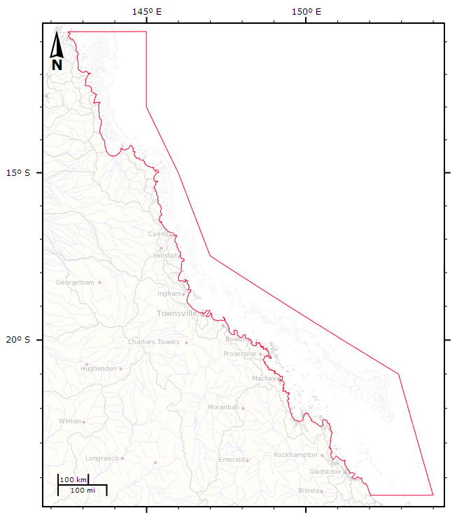
Boundaries of the Great Barrier Reef Marine Park proclaimed under Subsection 31(1) of the Great Barrier Reef Marine Park Act 1975 (CTH). For administrative purposes, the Amalgamated Great Barrier Reef Section is divided into four management areas. This metadata record was created for the eAtlas and is not authoritative. Please contact GBRMPA for more information. To obtain this dataset go to the GBRMPA spatial information website, download the appropriate data usage agreement and send it through to gis@gbrmpa.gov.au.
-
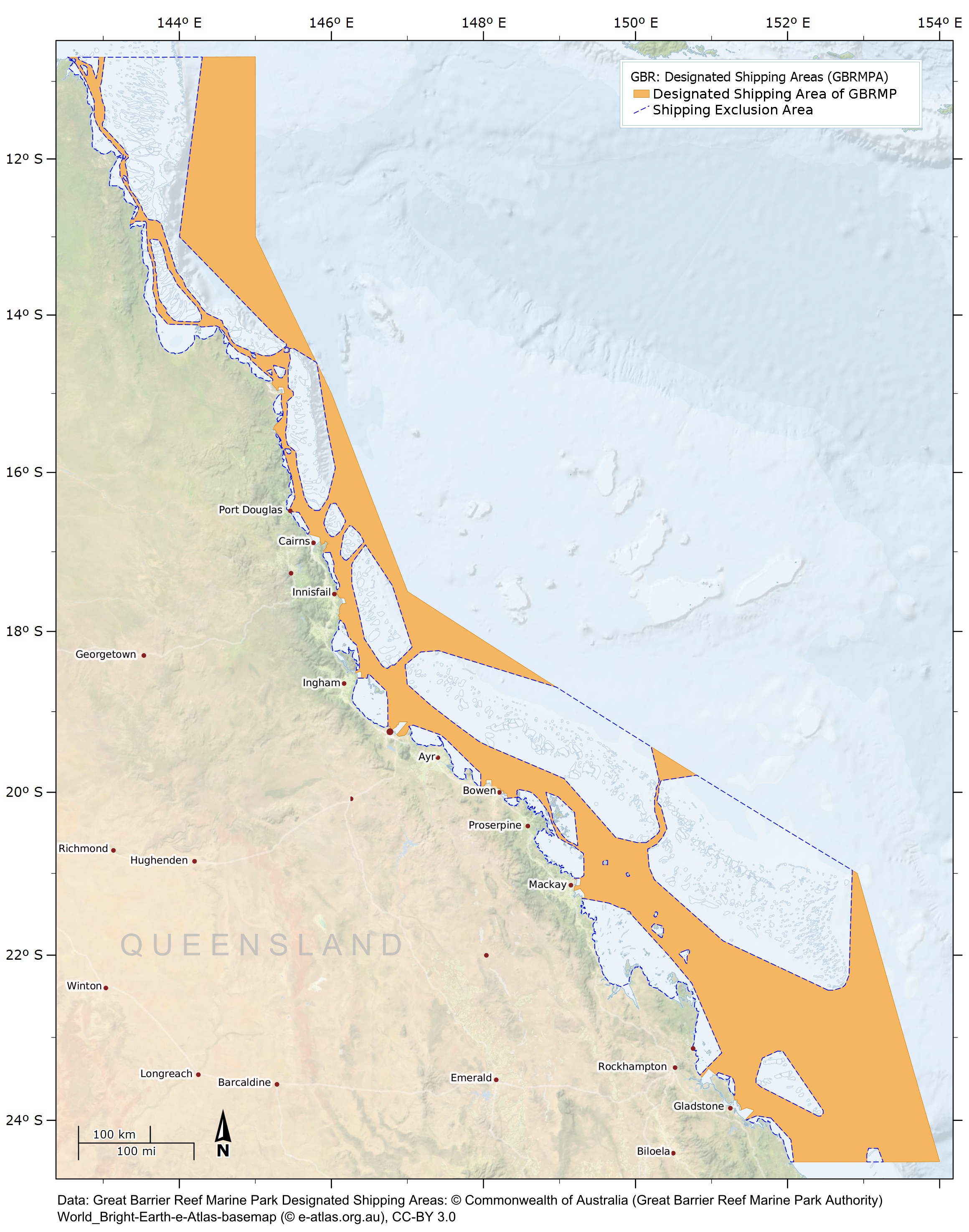
There are 10 major trading ports along the Great Barrier Reef coast. The waters of most of these ports are within the Great Barrier Reef Region, but not within the Great Barrier Reef Marine Park. In recognition of the outstanding values of the Great Barrier Reef, there are stringent management arrangements for commercial shipping in the waters of the Great Barrier Reef, which is designated a Particularly Sensitive Sea Area by the International Maritime Organisation. Shipping traffic is confined to Designated Shipping Areas in the Great Barrier Reef Region. This dataset shows the boundaries of the Designated Shipping Areas of the Great Barrier Reef Marine Park proclaimed under Section 59 of the Great Barrier Reef Marine Park Act 1975 (CTH) and described in in Part 10 of Schedule 1 of the Great Barrier Reef Zoning Plan 2003. This metadata record was created for the eAtlas and is not authoritative. Please contact GBRMPA for more information. To obtain this dataset go to the GBRMPA spatial information website, download the appropriate data usage agreement and send it through to gis@gbrmpa.gov.au. To cite this dataset in the eAtlas: Great Barrier Reef Marine Park Authority, (2004). Great Barrier Reef Marine Park Designated Shipping Areas. eAtlas Archive. https://eatlas.org.au/data/uuid/bd292772-4fef-4fa0-87b2-bf35367c06f2
-
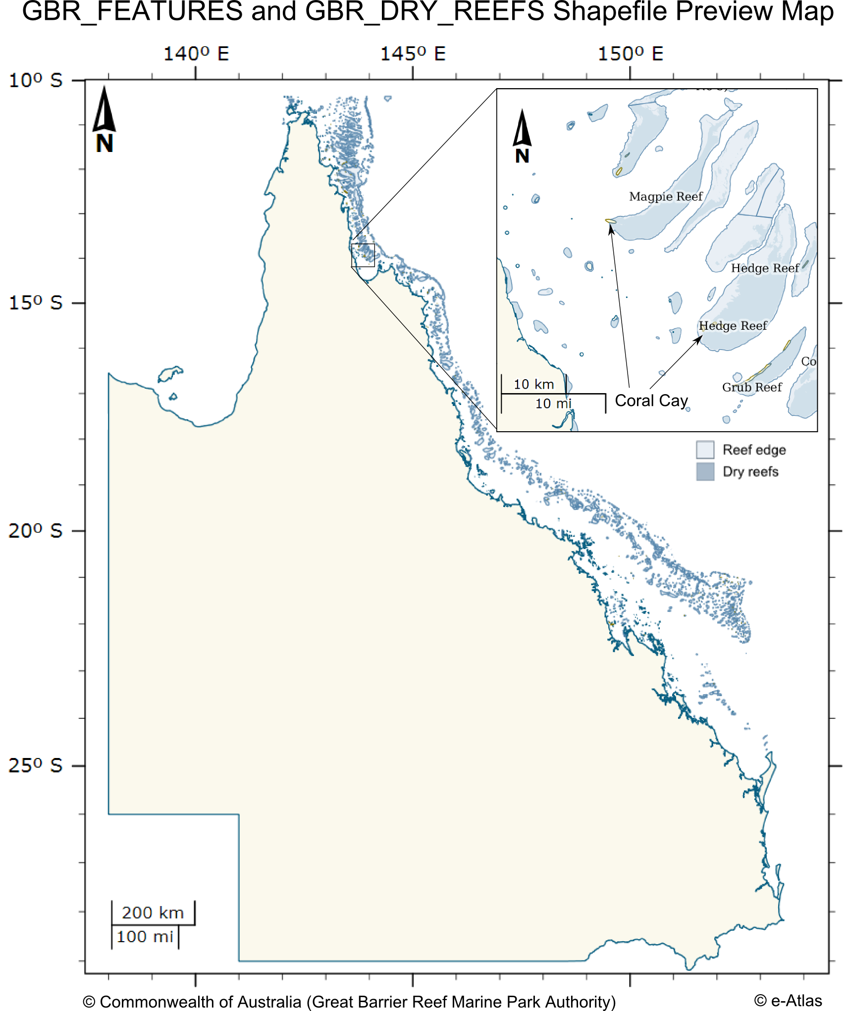
This dataset contains coastal features within and adjacent to the Great Barrier Reef World Heritage area. This dataset consists of two shapefiles GBR_FEATURES.shp and GBR_DRY_REEF.shp. The GBR_FEATURES shapefile contains the following features: * Queensland mainland coastline, * Major and other coral reef structures (as defined by the reef shoal edge), * Islands and rocks (exposed and submerged), * Major coral cay features. The GBR_DRY_REEFS contains major coral reef structures (as defined by the reef shoal edge) that are tidal, drying or emergent reef areas. The reef features extend north above the GBRWHA to just within the Torres Strait region. The features have not been statistically tested with precision survey techniques. Positional accuracy varies considerably and dataset should NOT be used for navigation purposes, however, for general use the coverage can be regarded as having a nominal scale of 1:250,000. This dataset corresponds to the zoning within the Great Barrier Reef Marine Park effective 1st July 2004. It is derived from the Great Barrier Reef Marine Park Zoning Plan 2003. The Great Barrier Reef Marine Park is a multiple-use area. Zoning helps to manage and protect the values of the Marine Park that users enjoy. Zoning Plans define what activities occur in which locations both to protect the marine environment and to separate potentially conflicting activities. Revised zoning of the Great Barrier Reef Marine Park was introduced in July 2004 as part of the Great Barrier Reef Marine Park Authority's Representative Areas Programme. Between 1999 and 2004, the Great Barrier Reef Marine Park Authority undertook a systematic planning and consultative program to develop new zoning for the Marine Park. The primary aim of the program was to better protect the range of biodiversity in the Great Barrier Reef, by increasing the extent of no-take areas (or highly protected areas, locally known as ‘Green Zones’), ensuring they included 'representative' examples of all different habitat types - hence the name, the Representative Areas Program or RAP. Whilst increasing the protection of biodiversity, a further aim was to maximise the benefits and minimise the negative impacts of the rezoning on the existing users of the Marine Park. Both these aims were achieved by a comprehensive program of scientific input, community involvement and innovation [1]. In each zones there are a range of activities that are allowed, disallowed or require a permit. The following outlines a summary of activities that are disallowed in each zone. Please refer to [2] for a more detailed and authoritative description of all restrictions within each zone: * General Use Zone: General use, some activities require a permit. * Habitat Protection Zone: No trawling, some activities require permits. * Conservation Park Zone: No trawling, limited crabbing and line fishing. * Buffer Zone: No aquaculture, bait netting, crabbing, harvesting fishing, collecting, spearfishing, line fishing, netting and trawling. Trolling for pelagic fish is allowed. * Scientific Research Zone: Research areas primarily around scientific research facilities. Same as Buffer zone but with no trolling. * Marine National Park Zone (Green): 'no-take' area. The following are allowed: boating, diving, photography and limited impact research. Some other activities are allowed with permits. * Preservation Zone (Pink): 'no go' area. No activities are allowed except research activities with a permit. Official maps derived from this dataset can be downloaded from the GBRMPA Zoning Maps [3] page. This dataset can now be downloaded directly from GBRMPA's Geoportal. Note: This metadata record was created for the eAtlas and is not authoritative. Please contact GBRMPA for more information. GBR_FEATURES.shp: Polygon Vector Shape file (5376 features) GBR_ID: A number that is made up of a two-digit number representing the latitude band the feature is in (LAT_ID) and a three or four-digit number representing the sequential number of a particular feature complex (GROUP_ID), e.g. an island with an adjacent reef/cay/rock etc should have the same GROUP_ID (19-051) SORT_GBR_I: A whole number for sorting (19051) GBR_NAME: Great Barrier Reef MP Name (Five Trees Cay (No 1)) QLD_NAME: Queensland Name (Five Trees Cay (No 1)) FEATURE_C: a three-digit number representing the type of feature, e,g mainland, island, cay etc (102) FEAT_NAME: Name of feature (Cay, Island, Mainland, Reef, Rock, Sand) SUB_NO: a two-digit number that is linked to the SUB_ID of a feature. The SUB_ID is a letter that identifies multiple features of the same type in a group, e.g. multiple reefs surrounding an island are labelled a, b, c, d etc - these will be numbered 101, 102, 103, 104 etc. If the SUB_ID is "s", it refers to a single feature and will be given the number 100 (101) LABEL_ID: GBR_ID plus SUB_ID if not an S (S is a singular feature and does not need a sub-id label) (19-051a) X_COORD: Centroid of feature (in Geographics GDA94 decimal degrees) (150.221849) Y_COORD: Centroid of feature (in Geographics GDA94 decimal degrees) (-22.227123) CODE: GBR_ID plus SUB_NO plus FEATURE_CODE with hyphens (19-051-101-102) UNIQUE_ID: GBR_ID plus SUB_NO plus FEATURE_CODE with no hyphens. This is to be used as the unique ID for the oracle database (19051102101) GBR_DRY_REEFS.shp: This shows areas of the reef that dry or the tops of the reefs. Polygon Vector Shape file (2318 features)
-
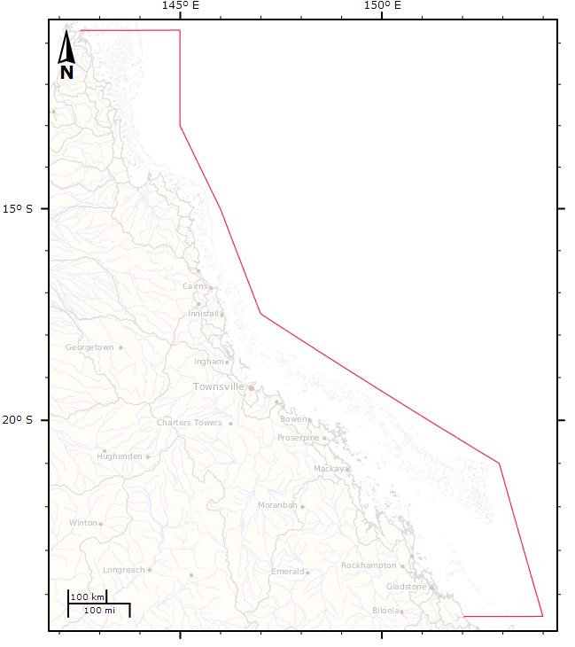
This dataset shows the ocean side boundary of the Great Barrier Reef Marine Park, excluding the inner boundary along the Queensland coastline. This dataset was derived from the Great Barrier Reef Marine Park Boundary dataset by loading the GBRMPA_BOUNDS_Line.shp (supplied by GBRMPA) into ArcMap then deleting the verticies along the coastline, breaking the original closed line loop. This dataset is not authorive and was produced for use in the eAtlas. Contact the Spatial Data Centre at GBRMPA for the official boundaries.